| |
| Home | |
| FAQ | |
| Player | |
| Utilities | |
| Stage | |
| Gazebo | |
| Contrib | |
| Documentation | |
| Publications | |
| Contributors | |
| Users |
| Project |
| Download |
| Bugs/Feedback |
| Mailing lists |
| Radish |
| Old news |
| Old stuff |
 |
Terrain Builder Utility
The terrain builder processes an elevation data file and outputs a binary data file loadable by the Terrain model. The input file can be of any type loadable by GDAL, see http://www.gdal.org/formats_list.html for a complete list.Basic usage is as follows:
$ gzbuilder [options] -i <inputfile> -o <outputfile>
where [options] is one or more of the following:
- Parameters:
-
-i <filename> Input terrain file. -o <filename> Output Gazebo terrain file. -e <double> Acceptable error bound on terrain approximation (meters). Set this to zero for no approximation. -h <double> Horizontal scaling factor (m). -v <double> Vertical scaling factor (m). -n Normalize Z-values before scaling. -x <double> X offset (m). -y <double> Y offset (m). -z <double> Z offset (m). -u <int> UTM zone. Default is 11 -s <double> X size of texture (meters) -t <double> Y size of texture (meters)
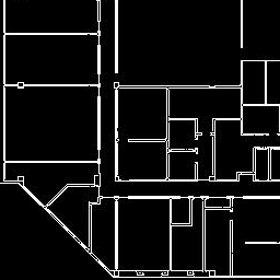
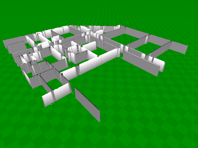
- Example: Building a maze

Input image

Output terrain
$ gzbuilder -i maze.gif -o maze.gzb -n -v 1.8 -h 0.1 -e 0.1
where the options are:
-n: Normalize the input image values in the range 0 (black) to 1 (white).
-v1.8 : Scale heights such that white pixels correspond to an elevation of 1.8m.
-h0.1 : Scale image such that each pixel corresponds to a horizontal distance of 0.1m (i.e., a 10cm grid spacing).
-e0.1 : Generate an approximated terrain whose maximum elevation error is no more than 0.1m.
Note changing the error parameter can radically alter the output terrain: setting this value too low will result in a slow simulation (many vertices); setting this value too high will result in a "melted" maze.
By default, the terrain is located such that the bottom-left corner of the image maps to (0, 0) in simulator coordinates. This can be offset using the xyz tag in the Terrain model.
Note also that the terrain can be arbitrarily translated and rotated by the terrain model; by
- Example: Building and using a geo-registered terrain
-u UTM zone option) and store this offset the terrain file. One can also take a simple image (with no lat/lon/alt data), and apply an arbitrary UTM offset using the -x -y -z options.When using geo-registered terrains, it is necessary to define a UTM offset in the global parameters section of the world file. This offset governs the transformation between simulation coordinates and UTM coordinates; i.e., the point (0, 0, 0) in the simulation frame is mapped to point (utmOffset.x, utmOffset.y, utmOffset.z) in the UTM frame. The UTM coordinates printed by the terrain builder may be used for this purpose.
- Output File Format
1..VertexCount of vertex datum followed by 1..IndexCount of index datum followed by 1..ODEIndexCount of ODE index datum.All data is in network byte order, and each value is 4 bytes in length.
A multiplication factor must be divided back out upon reading a value.
| Header | |
|---|---|
| Value Description | Original Data Type |
| version number * 1e3 | float |
| X-offset Whole | int |
| X-offset Fractional * 1e6 | float |
| Y-offset Whole | int |
| Y-offset Fractional * 1e6 | float |
| Z-offset Whole | int |
| Z-offset Fractional * 1e6 | float |
| Vertex Count | int |
| Index Count | int |
| ODE Index Count | int |
For Each Vertex:
| Vertex Datum | |
|---|---|
| Value Description | Original Data Type |
| S Texture Coord * 1e3 | float |
| T Texture Coord * 1e3 | float |
| Red Color * 1e3 | float |
| Green Color * 1e3 | float |
| Blue Color * 1e3 | float |
| Alpha Color * 1e3 | float |
| X Normal * 1e3 | float |
| Y Normal * 1e3 | float |
| Z Normal * 1e3 | float |
| X Position * 1e3 | float |
| Y Position * 1e3 | float |
| Z Position * 1e3 | float |
For Each Index:
| Index Datum | |
|---|---|
| Value Description | Original Data Type |
| Index Value | int |
For Each ODE Index:
| Index Datum | |
|---|---|
| Value Description | Original Data Type |
| ODE Index Value | int |
 1.4.2
1.4.2